Muddy Trail Status
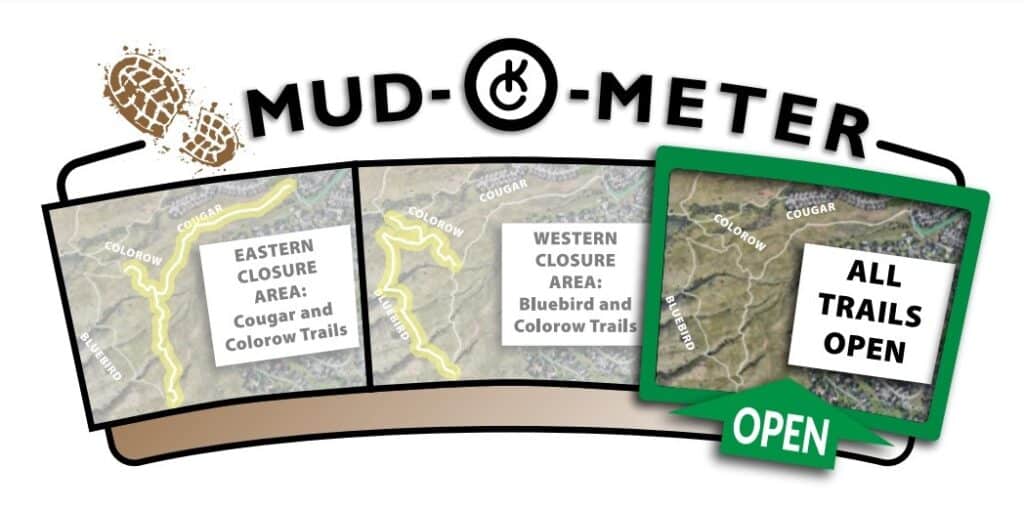
All trails open as of March 24.
Trail Closures for Muddy Conditions
Use of muddy trails has become a concern of many land management agencies. Extended use on muddy surfaces can lead to erosion, and trail users can create additional trail widening by going around muddy sections. Community leaders have directed the Ranger Staff to develop a trail closure policy for times when trails are muddy enough to cause damage to the trail tread.
The Ranger staff will evaluate and close trails when they are determined to be too muddy for sustainable use. The trail closure status will be updated to the public through the Ken-Caryl Ranch website and Facebook Page. The Ranger staff will monitor sections of trail throughout the shoulder and winter seasons.
Trail Information
Enjoy breathtaking views and wildlife in more than 4,800 acres of foothills open space. Over 45 miles of hiking, mountain biking and equestrian trails are ready for the exploration of our residents! Trails in the foothills and hogbacks are unpaved while those found nearer residential areas are generally paved and more accessible to all users. Trails are patrolled regularly.
Open Space Use ID Bracelets
Open Space Bracelets for 2022-2024
If you have an ORANGE open space ID bracelet it is no longer valid past Dec. 31, 2021. To obtain a new yellow ID bracelet, which will be good until 2024, please visit the Ranch House or the Community Center during the following hours:
Ranch House (7676 S. Continental Divide Rd.)
Monday – Thursday, 9 a.m. – 4 p.m.
Community Center (1 Club Dr.)
- Monday – Thursday, 6 a.m. – 7 p.m.
- Friday, 6 a.m. – 5 p.m.
- Saturday, 8 a.m. – 4 p.m.
We have simplified the registration process and it will take just a minute to grab your bracelets and be on your way.
If you are the homeowner, you will just need a photo ID. If you rent your home or are not the owner, you can provide any one of the following as address verification:
- A valid Colorado Driver’s License or Colorado I.D. with current KCR address.
- A valid Colorado I.D. with current KCR address.
- A valid property tax statement with the applicant’s name for the current KCR address.
- A valid warranty deed with the applicant’s name for the current KCR address.
- A valid lease/rental agreement with the applicant’s name for the current KCR address.
- A recent utility bill (gas, water, electric, cable) with the applicant’s name and current KCR address.
Most of our trails are on Ken-Caryl Ranch Private Open Space and are accessible only to members and their guests. Open space bracelets help rangers and volunteer patrollers quickly identify residents. It is not mandatory to have an ID bracelet when using Ken-Caryl Ranch Open Space, but if you don’t have an ID bracelet, please be prepared to stop and answer questions from a Park Ranger or Volunteer Patroller.
There is no cost for open space bracelets. Bracelets are issued only two per household and can be temporarily transferred to house guests ONLY while they are staying in your home. Other guests must be accompanied by a Ken-Caryl resident.
Proper areas to display the bracelets:
• HIKER/RUNNER – On wrist, waist, backpack strap or on a dog leash handle.
• BIKER – The handlebars near the stem is best.
• EQUESTRIAN – Saddle strap in front of the leg
E-Bikes
Unauthorized vehicles are prohibited, which includes, but is not limited to, motorcycles, motorized scooters, and any other motorized vehicles. Class 1 e-bikes are allowed on natural surface and paved open space, greenbelt, and park trails. Class 2 e-bikes are only allowed on paved open space, greenbelt, and park trails. Class 3 e-bikes are only allowed on roads and parking lots where motorized vehicles are authorized to travel. However, “Other Power-Driven Mobility Devices” (OPDMD) are allowed on open space, greenbelt, and park trails in accordance with “Guidelines for use of OPDMD on properties owned or leased by KCRMD and KCRMA.”
Open Space Group Events
Any group event by Ken-Caryl Ranch (KCR) residents and/or non-residents impacting or having the potential to impact open space property and/or interfere with other open space users must complete and submit a Group Event Application Form (button below) to the MA Staff and may be required to possess a valid permit. See the Group Event Policy (button below) for more information.
Public Trail Descriptions
Cathy Johnson and Columbine Trails and South Hogback Open Space – Open to the General Public
Length:
2.1 miles from South Valley Road to Deer Creek Canyon Road
Effort:
Easy to Moderate
Features:
Cathy Johnson Trail, which also serves as a service road for the Rangers, is situated in a narrow strike valley between the Dakota and Lyons Hogbacks. The Columbine Trail creates a loop off of the Cathy Johnson Trail, climbing onto the east flank of the Lyons Hogback and connects with Jefferson County’s South Valley Park.
Contact the Rangers for more information at 303-979-1876, ext. 170 or email Sean Warren.
Camping
Six campsites are available for Ken-Caryl Ranch residents and their guests in the Open Space. These beautiful, private campsites are available just outside your back door! The majority of the sites are primitive backcountry sites without restrooms or water.
$65
Bradford Open Space
The Bradford Open Space can be reserved for $60 per 24-hour block of time. To use the fire pit, you must check out a fire extinguisher at the Ranch House.
Reservations must be requested in advance through our registration portal.
Enjoy Outdoors
Campsite Reservations
All campsites (except Bradford Open Space) are free and on a first-come, first-served basis but must be reserved at the self-serve station located outside at the Dakota Lodge. At the self-serve station, enter your name, address, date, campsite, and permit number on the reservation sheet in the self-serve box. Make the permit visible at the campsite by hanging it on the post’s hook.
Campsites

BRADFORD OPEN SPACE
Private; for residents only. Mowed area behind the restored ruins of the Bradford Perley House, which was built in 1859. Sits within mixed grasslands and backs to a historic apple orchard. Dramatic red rock formations dominate the landscape.

GOTHIC OVERLOOK
Private; for residents only. Clearings A or B near the east end of Gothic Overlook Trail. The site is dominated by Gambel oak and mountain mahogany shrubs with great views of the valley and Denver.

MANOR HOUSE
Private; for residents only. Clearings A or B south of the picnic shelter, or site C in front of the old corral in the meadow south of Little John’s Chimney Trail. (See map). Near the top of Manor House trail, this site is tucked between oaks and ponderosa pine on the edge of a meadow that fills with wildflowers in spring. Campers can view Mt. Evans to the NW on clear days.

NORTH HOGBACK
Private; for residents only. East side of North Hogback Trail, 50′ north of the picnic shelter. This campsite lies between the Dakota and Lyons Hogbacks in a valley with mixed grasses and occasional narrow-leaf yucca clusters.

SILVER CLIFF
Private; for residents only. Clearing 50′ south of Bradford Trail. One of the park’s more secluded offerings. With a covering of oak and mature Ponderosa pine, campers have a southeasterly facing view of the foothills and Pike National Forest beyond.

TIN CUP
Private; for residents only. Clearing north of Bradford Trail, marked by a sign. The park’s highest campsite may take its name from a community on Colorado’s Western Slope. At more than 7,800 feet above sea level, Tin Cup has spectacular views of the open space.